Date: 2.28.2014
Location: <1.0 Miles North of Kensett, AR
Observed: Strong Inflow, Rain-Wrapped Tornado, Lightning
Chase Miles: 101 Miles
Total Miles: 180 Miles
Summary: What originally seemed like a severe weather day targeting Arkansas, the day of the event featured a Moderate Risk of severe weather in Illinois while north-central Arkansas was placed in an Enhanced Risk of severe weather. Jonesboro began to feel like a classic spring afternoon by noon time and the threat for severe weather remained rather questionable. While the parameters in Arkansas, specially north-central Arkansas, seemed fairly potent, storm initiation was questionable in the warm sector as a result of a lack of forcing. By late morning the HRRR was initiating a supercell and traversed it through central Arkansas well into the evening hours. Ultimately I decided by mid-afternoon I was not going to chase the event and did not think that convection would initiate the way the HRRR was advertising. By 5pm, I realized that perhaps I had made a mistake. A large supercell began to revolutionize from a rather messy cluster of convection moving towards I-40 between Little Rock and Conway. I noticed that an abundance of chasers were lined up along this stretch of interstate but no one was on US-67 from Little Rock to Newport. I felt as though the storm would likely get cranking after nightfall when backing surface winds would couple with a strong LLJ that would ultimately enhance tornado potential. So, by around 5:30pm, I blasted south on US-67 in hopes of beating this supercell to crossing the highway. As the supercell essentially went parallel to the highway, I noticed that the storm was getting very organized and showed a rather prominent and strengthening area of rotation. I initially targeted Higginson, AR but decided that I would remain north of Kensett, AR rather than actually go into the town and face the risk of getting hit by a possible tornado. I parked about 0.8-0.9 miles north of Kensett and was rocked by very strong inflow winds blowing into the now rain-wrapped tornado. These winds were easily 80 to even 90mph and were shifting from the NNW to the E (I was positioned north of the tornado.) The winds rocked the truck and blew out a street light as well as blew a lot of trash around. I was too far north to actually experience the tornado, but I was very fortunate to have not gone into the town as it sustained EF-2 tornado damage.
Analysis:
SPC Day 1 Outlook (2000z):

SPC Day 1 Tornado Probabilities (2000z):

SPC Tornado Watch:

SPC Storm Reports:

850mb Winds at 00z:

Surface Winds at 2307z:

Radar:
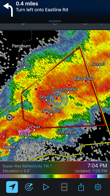
 Base Velocity showing strong rotation at approximately 2.7kft from KLZK Radar
Photos:

Only photo that was worthy of posting. This was a still from the dashcam. Video was not worth the time to post.
Citations:
http://www.spc.noaa.gov/exper/archive/event.php?date=20170301
http://www2.mmm.ucar.edu/imagearchive/
https://radarscope.io (on iPhone)
Location: <1.0 Miles North of Kensett, AR
Observed: Strong Inflow, Rain-Wrapped Tornado, Lightning
Chase Miles: 101 Miles
Total Miles: 180 Miles
Summary: What originally seemed like a severe weather day targeting Arkansas, the day of the event featured a Moderate Risk of severe weather in Illinois while north-central Arkansas was placed in an Enhanced Risk of severe weather. Jonesboro began to feel like a classic spring afternoon by noon time and the threat for severe weather remained rather questionable. While the parameters in Arkansas, specially north-central Arkansas, seemed fairly potent, storm initiation was questionable in the warm sector as a result of a lack of forcing. By late morning the HRRR was initiating a supercell and traversed it through central Arkansas well into the evening hours. Ultimately I decided by mid-afternoon I was not going to chase the event and did not think that convection would initiate the way the HRRR was advertising. By 5pm, I realized that perhaps I had made a mistake. A large supercell began to revolutionize from a rather messy cluster of convection moving towards I-40 between Little Rock and Conway. I noticed that an abundance of chasers were lined up along this stretch of interstate but no one was on US-67 from Little Rock to Newport. I felt as though the storm would likely get cranking after nightfall when backing surface winds would couple with a strong LLJ that would ultimately enhance tornado potential. So, by around 5:30pm, I blasted south on US-67 in hopes of beating this supercell to crossing the highway. As the supercell essentially went parallel to the highway, I noticed that the storm was getting very organized and showed a rather prominent and strengthening area of rotation. I initially targeted Higginson, AR but decided that I would remain north of Kensett, AR rather than actually go into the town and face the risk of getting hit by a possible tornado. I parked about 0.8-0.9 miles north of Kensett and was rocked by very strong inflow winds blowing into the now rain-wrapped tornado. These winds were easily 80 to even 90mph and were shifting from the NNW to the E (I was positioned north of the tornado.) The winds rocked the truck and blew out a street light as well as blew a lot of trash around. I was too far north to actually experience the tornado, but I was very fortunate to have not gone into the town as it sustained EF-2 tornado damage.
Analysis:
SPC Day 1 Outlook (2000z):

SPC Day 1 Tornado Probabilities (2000z):

SPC Tornado Watch:

SPC Storm Reports:

850mb Winds at 00z:

Surface Winds at 2307z:

Radar:
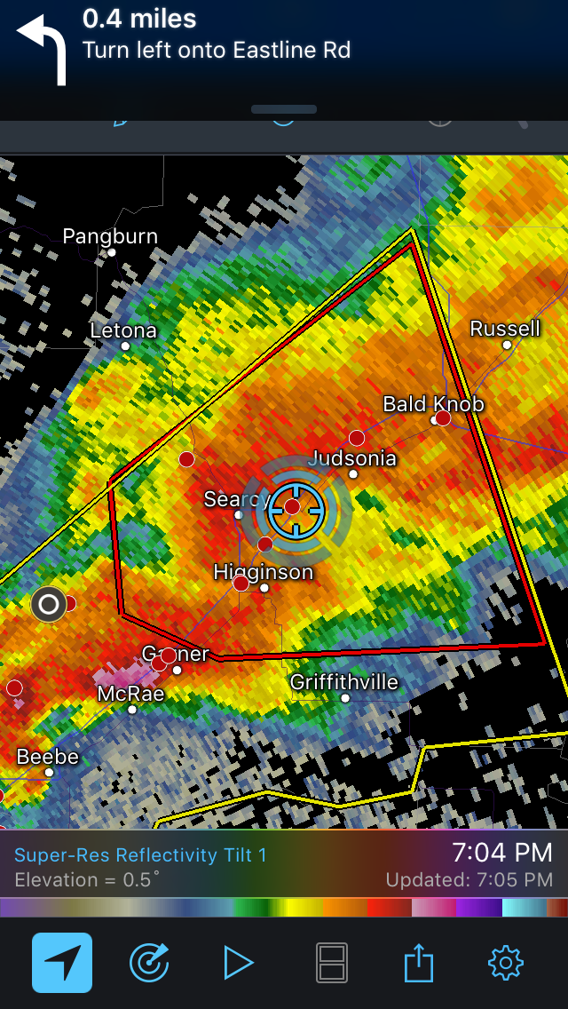
Base Reflectivity showing the rain-wrapped EF-2 tornado in progress to my south

Photos:
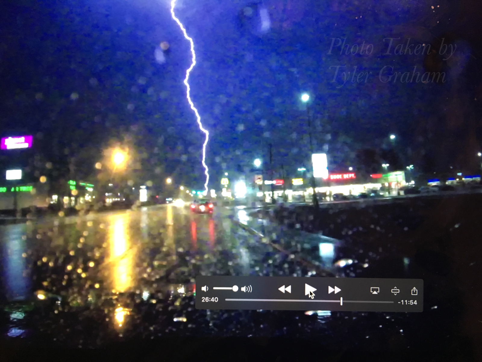
Only photo that was worthy of posting. This was a still from the dashcam. Video was not worth the time to post.
Citations:
http://www.spc.noaa.gov/exper/archive/event.php?date=20170301
http://www2.mmm.ucar.edu/imagearchive/
https://radarscope.io (on iPhone)